15. April 2016
5
15
/04
/April
/2016
05:13
Die schwarzen Strände auf Teneriffa bildeten sich aus Vulkanlava. Das Gestein wurde im Laufe der Zeit in die Brandungsregion gebracht und hier von den Wellen zermalmt. Zur Mittagszeit ist es ganz schön heiß hier – beim besten Willen, man kann den Strand nicht ohne Schuhe betreten.
-
The black beaches in Tenerife formed from volcanic lava. The rock was brought into the surf region over time and here crushed by the waves. At lunchtime it is very hothere - the best of intentions, one can not enter without shoes the beach.
-
Las playas negras en Tenerife forman a partir de lava volcánica. La roca fue traída a la región de surf con el tiempo y aquí aplastado por las olas. A la hora del almuerzo es muy caliente aquí - la mejor de las intenciones, uno no puede entrar sin zapatos de la playa.
Published by Malen und Zeichnen als Hobby
-
in
Fotografie
14. April 2016
4
14
/04
/April
/2016
02:02
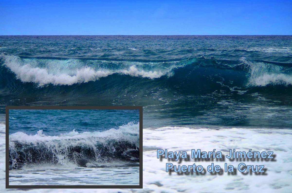
Playa María Jimenéz befindet sich auf der Insel Teneriffa in der Nähe von Puerto de la Cruz. Quer über die Straße geht es dann zum berühmten Zoopark, dem Loro Parque.
-
Playa María Jimenéz located at Tenerife Island near Puerto de la Cruz. Right across the street you go to the famous zoo park, the Loro Parque.
-
Playa María Jiménez situado en la isla de Tenerife, cerca de Puerto de la Cruz. Justo al otro lado de la calle que vaya al famoso parque zoológico, el Loro Parque.
Published by Malen und Zeichnen als Hobby
-
in
Fotografie
13. April 2016
3
13
/04
/April
/2016
05:58
Die Caldera Las Canadas auf der Insel Teneriffa bietet einige schöne Wanderwege. An vielen beeindruckenden Felsenformationen vorbei führt der Weg Nr. 2.
-
The Caldera Las Canadas on the island of Tenerife offers some lovely walks. At manyimpressive rock formations by path no. 2 performs.
-
La Caldera de Las Cañadas en la isla de Tenerife ofrece algunos paseos. En muchas formaciones rocosas impresionantes por el camino no. 2 realiza.
Published by Malen und Zeichnen als Hobby
-
in
Fotografie
12. April 2016
2
12
/04
/April
/2016
05:18
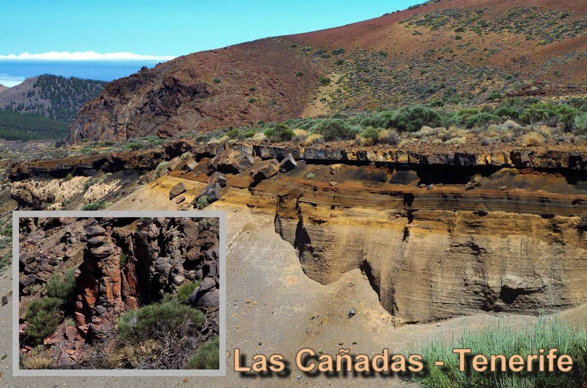
Der Wanderweg Sendero 2 führt an vielen interessanten Steinformationen vorbei. Vor den Augen entfaltet sich die Vergangenheit des Vulkans. Die stetigen Ausbrüche haben verschiedenfarbigen Schichten gebildet. Kleine Erdrutsche haben sie dann enthüllt, sodass wir sie heute bewundern können.
Sendero 2, Nationalpark, Teneriffa
-
The trail Sendero 2 passes many interesting rock formations. Before the eyes unfoldsthe history of the volcano. The steady eruptions have formed differently colored layers.Small landslides have then revealed, so that we can admire today.
Sendero 2, National Park, Tenerife
-
El sendero Sendero 2 pasa a muchas formaciones rocosas interesantes. Antes de que los ojos se desarrolla la historia del volcán. Las erupciones constantes han formadocapas de diferente color. Pequeños deslizamientos continuación, han puesto de manifiesto, de manera que hoy podemos admirar.
Sendero 2, Parque Nacional, Tenerife
Published by Malen und Zeichnen als Hobby
-
in
Fotografie
11. April 2016
1
11
/04
/April
/2016
05:14
Die Caldera des ehemaligen Vulkans auf Teneriffa ist über die Straße gut zu erreichen. In der Caldera befinden sich einige Wanderwege. Der Weg Nr. 2 (Sendero 2) startet gegenüber dem Centro de Visitantes, dem Informationszentrum des Nationalparks. Es ist ein Rundweg. Er führt an zauberhaften Felsformationen vorbei, um zurück zum Anfangspunkt zu kommen.
Sendero 2 - Arenas Negras – ist ca. 8,5 km lang mit einem Höhenunterschied von 250 m. Sie werden ungefähr 3 oder 4 Stunden brauchen.
-
The caldera of an extinct volcano on Tenerife is easy to reach by road. In the calderathere are several hiking trails. The road no. 2 (Sendero 2) starts opposite the Centro deVisitantes, the information center of the National Park. It is a circular route. It leads past enchanting rock formations to come back to the starting point.
Sendero 2 - Arenas Negras - is about 8.5 km long with a vertical drop of 250 m. You will need about 3 or 4 hours.
-
La caldera de un volcán extinguido en Tenerife es de fácil acceso por carretera. En la caldera hay varias rutas de senderismo. El camino no. 2 (Sendero 2) comienzaenfrente del Centro de Visitantes, el centro de información del Parque Nacional. Se trata de una ruta circular. Conduce últimas formaciones rocosas encantador para volver al punto de partida.
Sendero 2 - Arenas Negras - es alrededor de 8,5 km de longitud con un desnivel de250 m. Se necesitan unos 3 o 4 horas.
Published by Malen und Zeichnen als Hobby
-
in
Fotografie
10. April 2016
7
10
/04
/April
/2016
05:49
Gipfel des größten Berg Spaniens – Pico del Teide. Im unteren Teil des Fotos – Blick in den Norden. Passatwinde bringen an die nördliche Küste Teneriffas Wolken, die hier abregnen und für die grüne Vegetation im Norden der Insel sorgen. Sie kommen nicht über das Bergmassiv drüber. Daher ist der Süden der Insel trocken und ähnelt einer Wüste.
-
Summit of the biggest mountain of Spain - Pico del Teide. In the lower part of the photo- view to the north. Trade winds bring to the northern coast of Tenerife clouds that rain down here and take care of the green vegetation in the north of the island. Do notcome over the majestic about it. Therefore, the south of the island is dry and resembles a desert.
-
Cumbre de la montaña más grande de España - Pico del Teide. En la parte inferior de la foto - vista hacia el norte. Los vientos alisios traen a la costa norte de Tenerife nubesque llueven aquí y se ocupan de la vegetación verde en el norte de la isla. No vengasobre el majestuoso al respecto. Por lo tanto, el sur de la isla es seco y se asemeja aun desierto.
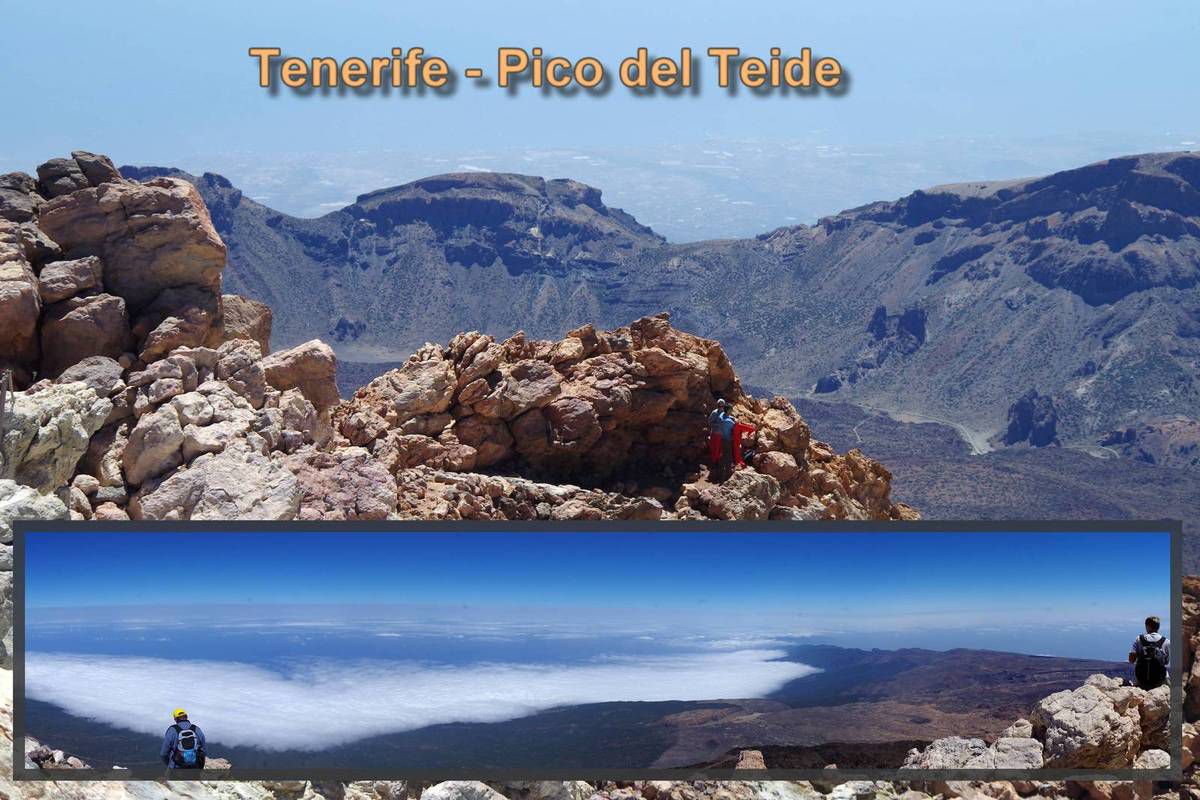
Gipfel des größten Berg Spaniens – Pico del Teide. Im unteren Teil des Fotos – Blick in den Norden. Passatwinde bringen an die nördliche Küste Teneriffas Wolken, die hier abregnen und für die grüne Vegetation im Norden der Insel sorgen. Sie kommen nicht über das Bergmassiv drüber. Daher ist der Süden der Insel trocken und ähnelt einer Wüste. - Summit of the biggest mountain of Spain - Pico del Teide. In the lower part of the photo- view to the north. Trade winds bring to the northern coast of Tenerife clouds that rain down here and take care of the green vegetation in the north of the island. Do notcome over the majestic about it. Therefore, the south of the island is dry and resembles a desert. - Cumbre de la montaña más grande de España - Pico del Teide. En la parte inferior de la foto - vista hacia el norte. Los vientos alisios traen a la costa norte de Tenerife nubesque llueven aquí y se ocupan de la vegetación verde en el norte de la isla. No vengasobre el majestuoso al respecto. Por lo tanto, el sur de la isla es seco y se asemeja aun desierto.
Published by Malen und Zeichnen als Hobby
-
in
Fotografie
9. April 2016
6
09
/04
/April
/2016
05:45
Heute sieht der Stein wie ein poröser Schwamm. Die Lava kam während der Eruption unter großem Druck aus der Erde. In ihrem Inneren befanden sich Gase. Sie sind für das heutige Aussehen der Steine verantwortlich.
Im oberen Teil – Blick vom Gipfel des Teide nach Osten. Im linken Bereich sehen Sie die Wolkendecke, die für den grünen Norden Teneriffas sorgt. Im Süden ist es dagegen trocken.
-
Today the stone looks like a porous sponge. The lava came during the eruption under great pressure from the earth. Inside there were gases. They are responsible for the present appearance of the stones.
In the upper part - view from the summit of Mount Teide to the east. On the left sideyou will see the cloud cover, which ensures the green north of Tenerife. In the south,however, it is dry.
-
Hoy en día la piedra se parece a una esponja porosa. La lava se produjo durante la erupción bajo una gran presión de la tierra. Dentro había gases. Ellos son responsables de la actual fisonomía de las piedras.
En la parte superior - vista desde la cumbre del Teide hacia el este. En el ladoizquierdo verá la cubierta de nubes, lo que asegura el verde norte de Tenerife. En el sur, sin embargo, es seco.

Heute sieht der Stein wie ein poröser Schwamm. Die Lava kam während der Eruption unter großem Druck aus der Erde. In ihrem Inneren befanden sich Gase. Sie sind für das heutige Aussehen der Steine verantwortlich. Im oberen Teil – Blick vom Gipfel des Teide nach Osten. Im linken Bereich sehen Sie die Wolkendecke, die für den grünen Norden Teneriffas sorgt. Im Süden ist es dagegen trocken. - Today the stone looks like a porous sponge. The lava came during the eruption under great pressure from the earth. Inside there were gases. They are responsible for the present appearance of the stones. In the upper part - view from the summit of Mount Teide to the east. On the left sideyou will see the cloud cover, which ensures the green north of Tenerife. In the south,however, it is dry. - Hoy en día la piedra se parece a una esponja porosa. La lava se produjo durante la erupción bajo una gran presión de la tierra. Dentro había gases. Ellos son responsables de la actual fisonomía de las piedras. En la parte superior - vista desde la cumbre del Teide hacia el este. En el ladoizquierdo verá la cubierta de nubes, lo que asegura el verde norte de Tenerife. En el sur, sin embargo, es seco.
Published by Malen und Zeichnen als Hobby
-
in
Fotografie
8. April 2016
5
08
/04
/April
/2016
08:42
Pico del Teide ist ein Schichtvulkan. Auf dem Weg zum Gipfel werden Sie beeindruckende Steinformationen sehen. Verschiedene Schichten von Lava aus früheren Ausbrüchen haben unterschiedliche Farben. Im Hintergrund des Fotos befindet sich die Caldera.
-
Pico del Teide is a stratovolcano. On the way to the top you will see impressive rock formations. Various layers of lava from previous eruptions have different colors. In the background of the photo, the Caldera is.
-
Pico del Teide es un volcán. En el camino a la parte superior podrás verimpresionantes formaciones rocosas. Varias capas de lava de las erupcionesanteriores tienen diferentes colores. En el fondo de la foto, la Caldera es.
Pico del Teide ist ein Schichtvulkan. Auf dem Weg zum Gipfel werden Sie beeindruckende Steinformationen sehen. Verschiedene Schichten von Lava aus früheren Ausbrüchen haben unterschiedliche Farben. Im Hintergrund des Fotos befindet sich die Caldera. - Pico del Teide is a stratovolcano. On the way to the top you will see impressive rock formations. Various layers of lava from previous eruptions have different colors. In the background of the photo, the Caldera is. - Pico del Teide es un volcán. En el camino a la parte superior podrás verimpresionantes formaciones rocosas. Varias capas de lava de las erupcionesanteriores tienen diferentes colores. En el fondo de la foto, la Caldera es.
Published by Malen und Zeichnen als Hobby
-
in
Fotografie
7. April 2016
4
07
/04
/April
/2016
03:45
Auf dem Gipfel des Teide kann man sich kurz hinsetzen, um sich auszuruhen. Vor Ihren Augen öffnet sich ein unvergessliches Panorama. Nahe dem Gipfel treten aus dem Vulkan Schwefelgase aus. Es bilden sich gelbe Ablagerungen, die Sie bewundern können.
Seltsammer Weise haben unsere noch recht kleinen Kinder den Aufstieg besser verkraftet, als wir Erwachsenen.
-
On the top of Teide you can sit briefly to rest. Before your eyes opens an unforgettable panorama. Near the summit emerge from the volcanic sulfur gases. Are formed yellow deposits, which can be admired.
Seltmann Sammer way our still quite young children have to climb better cope, as we adults.
-
En la parte superior del Teide se puede sentar a descansar brevemente. Antes de que sus ojos se abre un panorama inolvidable. Cerca de la cumbre emerger de los gases de azufre volcánico. Se forman depósitos amarillos, que se pueden admirar.
Seltmann Sammer forma en que nuestros hijos todavía muy jóvenes, tienen que subira lidiar mejor, ya que los adultos.
Published by Malen und Zeichnen als Hobby
-
in
Fotografie
6. April 2016
3
06
/04
/April
/2016
03:43
Der Teide selbst ist nicht in einem Schritt entstanden. Der Komplex TeidePico Viejo ist ein
Schichtvulkan, der sich durch die Anhäufung von Material aufeinanderfolgender Eruptionen bildete.
Der 200 Meter hohe Teidegipfel El Pitón entstand ebenfalls aus einem älteren Krater.
Für die Besteigung des Gipfels ist eine Genehmigung erforderlich, die man im Internet oder im
Büro der Nationalparkverwaltung in Santa Cruz de Tenerife erhält. Die Erlaubnis mit einem
Zeitfenster von zwei Stunden wird kostenlos erteilt, falls die Bedingungen auf dem Gipfel eine
Besteigung erlauben und das Kontingent für den entsprechenden Zeitraum noch nicht erschöpft ist.
Eine frühzeitige Reservierung ist ratsam.
Zum Gipfel führt der Wanderweg Sendero 10. Eingang befindet sich an der oberen Station der Teleferico del Teide. Der Weg hat einen hohen Schwierigkeitsgrad. Er ist zwar nur 614 Meter lang mit dem Höhenunterschied von ca. 180 m, man sollte aber nicht vergessen, dass er sich 3700 m über dem Meer befindet. Schon nach einer Minute spürt man beim dem Besteigen des Berges deutlich den Sauerstoffmangel.
-
The Teide itself is not created in a single step. The complex is a TeidePico Viejo
Stratovolcano, which formed by the accumulation of material successive eruptions.
The 200 meter high Teide summit El Pitón was also of an older crater.
For the climb to the summit require a license, the one on the Internet or
Office of the National Park Service in Santa Cruz de Tenerife obtains. Permission to a
Time window of two hours is granted for free, if the conditions on the summit
Climbing permit and the quota for the same period is not yet exhausted.
Early reservation is advisable.
To the Summit leads the trail Sendero 10. Entrance is located at the upper station of Teleferico del Teide. The road has a high degree of difficulty. Although he is only 614 meters long with the altitude difference of about 180 m, but one should not forget that he 3700 m is located above the sea. After one minute you can feel when embarking on the mountain clearly the lack of oxygen.
-
El propio Teide no se crea en un solo paso. El complejo es un Viejo TeidePico
Estratovolcán, que se formó por la acumulación de sucesivas erupciones materiales.
La alta cumbre del Teide 200 metros El Pitón era también de un cráter de más edad.
Para el ascenso a la cumbre requerir una licencia, la que está en Internet o
Oficina del Servicio de Parques Nacionales en Santa Cruz de Tenerife obtiene. La autorización para hacer una
ventana de tiempo de dos horas se hace a título gratuito, si las condiciones en la cumbre
Permiso de escalada y la cuota para el mismo período aún no se ha agotado.
reserva anticipada es aconsejable.
Para la Cumbre conduce el sendero Sendero 10. La entrada se encuentra en la estación superior del teleférico del Teide. La carretera tiene un alto grado de dificultad.A pesar de que está a sólo 614 metros de largo con la diferencia de altitud de unos 180 m, pero no hay que olvidar que 3700 m se encuentra por encima del mar.Después de un minuto se puede sentir cuando se embarca en la montaña con claridad la falta de oxígeno.
Published by Malen und Zeichnen als Hobby
-
in
Fotografie


/idata%2F2273638%2FFotoserie-3%2F528a.jpg)
/idata%2F2273638%2F6--malerei%2Ftanz-des-Glucks.jpg)
/idata%2F2273638%2FFotoserie-2%2F345adventkalender--4-.jpg)
/idata%2F2273638%2F5--malerei%2F340.jpg)
/idata%2F2273638%2FFotoserie%2F-196-196.jpg)
/idata%2F2273638%2F4--malerei%2F186-an-der-wand.jpg)
/idata%2F2273638%2FKunst-am-Turm-2012%2FP6240434_stitchkl.jpg)
/idata%2F2273638%2FFotokollagen%2F2.jpg)
/idata%2F2273638%2Fkompositionen%2FBetakampffisch.jpg)